Establishing a comprehensive, ecologically representative network of protected areas is critically importance to safeguarding global biodiversity. Countries are obligated through the CBD Programme of Work on Protected Areas (PoWPA) to identify gaps in their national protected area systems. Comparing the locations of Important Bird Areas (IBA) with those of existing protected areas is a simple yet effective way of finding where key species are left unprotected and can greatly assist countries in meeting their PoWPA commitments.
Protected areas are an essential tool for safeguarding biological diversity (Bruner et al. 2001). However, despite approaching 13% the earth’s terrestrial area (excluding Antarctica), the coverage of biodiversity by protected areas remains incomplete (WDPA 2010). The ad hoc nature of past reserve designation has left many sites of remarkably high conservation value unprotected (Rodrigues et al. 2004).

In February 2004, the Seventh Conference of the Parties to the Convention on Biological Diversity (CBD) developed a comprehensive Programme of Work on Protected Areas (PoWPA) with the aim of encouraging countries to establish and maintain comprehensive and ecologically representative networks of protected areas. As part of this commitment, governments were mandated to conduct a gap analysis to assess where their current protected area system fell short of adequately protecting biodiversity. Since this requires the collection, analysis and compilation of a wide variety of information, much of which is not readily available (particularly in developing countries), many nations have struggled to complete this undertaking.
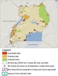
Important Bird Areas (IBAs) have been identified around the world using a set of standardised selection criteria based on threat and irreplaceability. Consequently, they can make a crucial contribution to identifying where there are gaps in the existing protected area system. Comparing the locations of IBAs with those of existing protected areas is a simple yet effective way of finding where key species are left unprotected or under-protected. Using spatial data from the World Bird Database and the World Database on Protected Areas (WDPA), gaps in protected area coverage can be identified and mapped (see figure). To date, BirdLife has carried out this analysis for more than 80 countries around the world.
To access currently available gap analysis maps click here.
Links
References
Compiled: 2011 Copyright: 2011
Recommended Citation:
BirdLife International (2011)
BirdLife Partners use IBAs to inform an ecologically representative network of protected areas.
Downloaded from https://datazone.birdlife.org/sowb/casestudy/birdlife-partners-use-ibas-to-inform-an-ecologically-representative-network-of-protected-areas on 22/12/2024