High Andean wetlands are fragile ecosystems on the desert-like high altitude plains of Bolivia. Their conservation is critical for the 36 species of resident and migratory waterbirds who use the ecosystem throughout the year. Participative methods with local communities identified the main threats affecting these wetlands: climate change, unregulated mining activities, habitat conversion through agriculture, and reduction in the area of the wetlands. Ecosystem services provided by the wetlands were also identified and evaluated, and finally, an Action Plan was drawn up to manage the Ramsar site.

Read this case study in Spanish
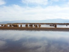
The Ramsar site of Lakes Poopó and UruUru has an area of approximately 1 million hectares and is located on the dry puna ecosystem of the high Andean plain, or Altiplano, in Central Bolivia. Both lakes are important wintering sites for austral migratory species, such as high Andean flamingos between May and November, and for Neartic migratory birds during the wet season, from November to March. Over the last five years, the total number of birds on these lakes has decreased drastically, by almost 50% in the case of resident species. Populations of Neartic migratory birds arriving at the wetlands only seem to spend a few days on both lakes before continuing their journey to the south of the continent. One endemic species of the Titicaca basin, the Endangered Titicaca Grebe Rollandia microptera has almost disappeared from Lake UruUru.
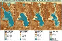
Lakes Poopó and UruUru have suffered a large reduction in their area of open water, with a multi-temporal analysis of satellite images over the last 25 years revealing a 47% loss. Additionally, the sedimentation and silting up of the lake bed has accelerated due to a variety of factors, including natural eutrophication, the inflow of almost untreated sewage from the city of Oruro, small- and large-scale unregulated mining activity, and changes in land use resulting from conversion of native grasslands to agriculture in the southern region of the Ramsar site.
Workshops and focal groups with local actors identified and assessed threats and ecosystem services at the site and then set out activities and guidelines for regional and local government, in coordination with civil society, to manage the Ramsar site as a regional protected area. An action plan to promote the management of the protected area was prepared with information from a participative process with local communities as well as the multi-temporal analysis of the wetland’s reduction in area. The integral management of the Ramsar site will depend on political will and the establishment of a committee to oversee the plan’s implementation. Currently, planning and management instruments in the Oruro province do not recognise the lakes and surrounding areas as a conservation area. However, they do recognise the importance of the sustainable management of natural resources within Lake Poopó basin, as well as the recovery of the grassland ecosystems, sustainable management of the vicuña populations, and the promotion of environmentally responsible tourism.
Related Case Studies in other sections
Related Sites
Related Species
References
Compiled: 2013 Copyright: 2013
Recommended Citation:
BirdLife International (2013)
Participative methods for conservation planning at Lakes Poopó and UruUru on the Bolivian Altiplano.
Downloaded from https://datazone.birdlife.org/participative-methods-for-conservation-planning-at-lakes-poopó-and-uruuru-on-the-bolivian-altiplano on 23/12/2024